A landslide is a general term for the downslope movement of rock, soil, or both under the influence of gravity and other forces. Climate, rock type, soils, landscape, and slope modification make parts of Kentucky landslide prone. Landslide susceptibility is defined as the relative tendency or potential for slope movement in an area. A landslide susceptibility map classifies or ranks slope stability based on relationships between variables that contribute to instability. This method differs from other types of landslide hazard maps, which may include elements of time or estimated landslide extent.
(zoomed to extent of mapped area)
(ESRI Geodatabase with rasters, symbolization layer files, and read me)
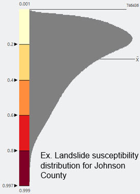
We classified the landslide susceptibility results in a GIS (Geographic Information Systems) using an equal interval scheme from a calculated probability that a landslide has occurred, is occurring, or will occur based upon a combination of landscape variables. Equal interval classification commonly works well with skewed data distribution (not normal distribution), focusing the high and low values and emphasizing the value to the rest of the map area. Equal interval will also allow a seamless uniform scheme across county boundaries. Other types of classifications aggregate distinctions between classes and are better for normally distributed data. The landslide susceptibility classes and sample distribution are detailed in the figures below.
Landslide Susceptibility
Probability
low
0.0 - 0.2
low-moderate
0.21 - 0.4
moderate
0.41 - 0.6
moderate-high
0.61 - 0.8
high
0.81 - 1.0
Methods
We developed an approach to landslide-susceptibility mapping combining machine-learning and geomorphic statistics (Crawford and others, 2021). The susceptibility model is based upon high-resolution airborne lidar-derived data sets from a 1.5-m regional digital elevation model and a detailed landslide inventory for Magoffin County, Kentucky. We used a logistic regression model to establish a connection between specific slope variables and landslide occurrence. We evaluated slope angle, aspect, elevation, terrain roughness, curvature, and plan curvature to determine what influences landslide occurrence. Next, we modeled the probability of occurrence and used those values to create a landslide susceptibility map. Our model and resulting map estimate the probability of an event (a landslide) determined by the slope variables.
The probability and map classification are not a landslide prediction result from a scenario-based event (a rainfall event, for example), or a probability with a time component. This means the map classification will not predict how or when a landslide might occur, only the likelihood of a past or future occurrence. Data that occurs on less than a 3-degree slope were excluded because these areas are mostly flat. Although determining landslide susceptibility has inherent uncertainty, our map results effectively reflect the geomorphic variables that are indicative of unstable ground conditions and potential landslide activity. The low-moderate and low susceptibility classes do not indicate that landslides have not or cannot occur in these areas.
Map Use and Limitations
This map is intended to help identify relative landslide susceptibility in eastern Kentucky. These maps are particularly important and useful because existing landslides are often susceptible to reactivation, which makes modeling the probability of occurrence and developing a susceptibility map with logistic regression a practical approach. An understanding of the slope-geomorphology variables that are most important to landslide occurrence supports landslide hazard communication, planning, and mitigation strategies, and reduces risk.
This map is not intended for site-specific slope stability decisions for individual structures or sites or for the prediction of future landslides. Our modeling technique and use of high-resolution elevation data sets generated some artifacts (model overprediction) in the susceptibility map results. This occurs most often with heavily modified parts of the landscape (large roadcuts and surface mines, primarily), where there are sharp unnatural breaks between steep slopes and flat, modified ground.
The map should be used only for regional or community-scale planning and mitigation purposes. The susceptibility classes do not indicate how far a landslide may be transported, or where landslide soil and rock material may be deposited. Future geologic, topographic, and landslide mapping may render this map locally inaccurate.
This work was funded by the Federal Emergency Management Agency (PDMC-PL-04-KY-2017-002).
Crawford, M.M., Dortch, J.M., Koch, H.J., Killen, A.A., Zhu, J., Zhu, Y., Bryson, L.S., and Haneberg, W.C. (2021) Using landslide-inventory for a combined bagged-trees and logistic regression approach to landslide susceptibility in eastern Kentucky, United States, Quarterly Journal of Engineering Geology and Hydrogeology, http://doi.org/10.1144/qjegh2020-177.