Welcome to the Parklands Of Floyds Fork Story Map Tour
Introduction
Floyds Fork is a half-mile-wide valley located 15 miles east of downtown Louisville, Ky. It extends 60 miles from the confluence of the north and east forks of Floyds Fork in Oldham County northeast of Louisville, to the Salt River at Shepherdsville in Bullitt County, southeast of Louisville. This tour covers a 7-mile portion of Floyds Fork in the Fisherville 7.5-minute quadrangle, extending from Valhalla Golf Club on the north end to Pope Lick Park of the Parklands of Floyds Fork on the south end. Seven-and-a-half-minute quadrangles are divisions of Earth's surface divided by latitude and longitude; each quadrangle is a rectangular area representing 7½ minutes of latitude by 7½ minutes of longitude. This is the standard mapping area for topographic quadrangle maps, (or approximately 7 x 10 miles) in Kentucky. Geologic quadrangle maps cover the same area, and the geology is mapped on top of the topography. Kentucky is one of the few states in the nation that has been completely geologically mapped on a 7.5-minute quadrangle basis. The scale of both the topographic and geologic maps is 1:24,000.

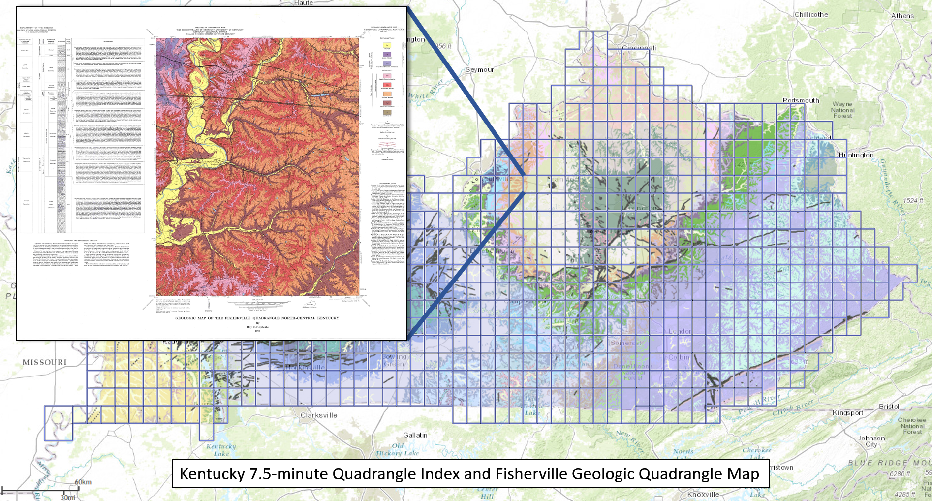
The location of the Fisherville 7.5-minute quadrangle is indicated on this map.
The tour begins at the William F. Miles Trailhead for the Louisville Loop in Beckley Creek Park (accessed from Beckley Creek Parkway off of Shelbyville Road), and focuses on the bedrock geology and overlying surficial deposits that comprise the Floyds Fork area. Park facilities are shown on this map.
Tour Logistics
The tour path is 8.9 miles in one direction, primarily traveling along the Louisville Loop trail. This tour is best traversed by bicycle, but can also be done by car (stopping at the recommended parking lots described in the text) and then by walking. If traveling by bicycle, please take proper safety precautions: Wear a helmet, be aware that pedestrians have the right of way, and please be courteous to other trail users by signaling your presence (a bell or calling out "On your left" works well). One section of this tour (stops 12 and 13) requires cycling on a lightly travelled road.
Explanation of Stops:
Bedrock geology
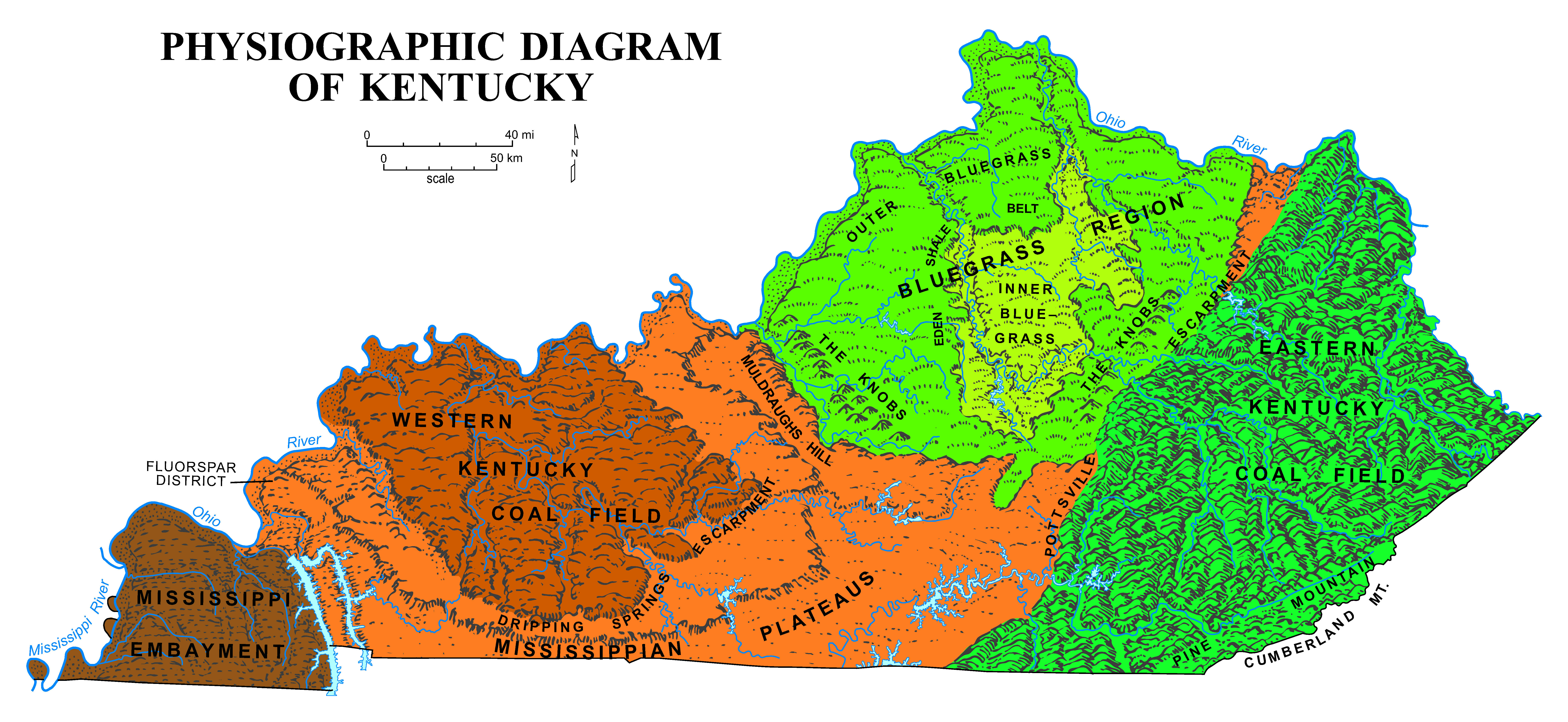
Floyds Fork is located in the Outer Bluegrass physiographic region, an area characterized by rolling hills and incised plateaus. All of the land within a particular physiographic region has similar geologic structure and topography. The surface topography of the Outer Bluegrass is underlain by limestone, dolomite, and shale. The region typically has low to moderate relief. Soils tend to be thicker over limestone bedrock than over shales, because the ridgetops and valley bottoms are underlain by limestone and hillslopes are underlain by shale. The bedrock across the trail is Late Ordovician in age. The dolomites and limestones contain fossils of corals and marine seashells, which indicates this area was covered by warm, shallow seas during the Late Ordovician Period, from 450 to 443 million years ago.

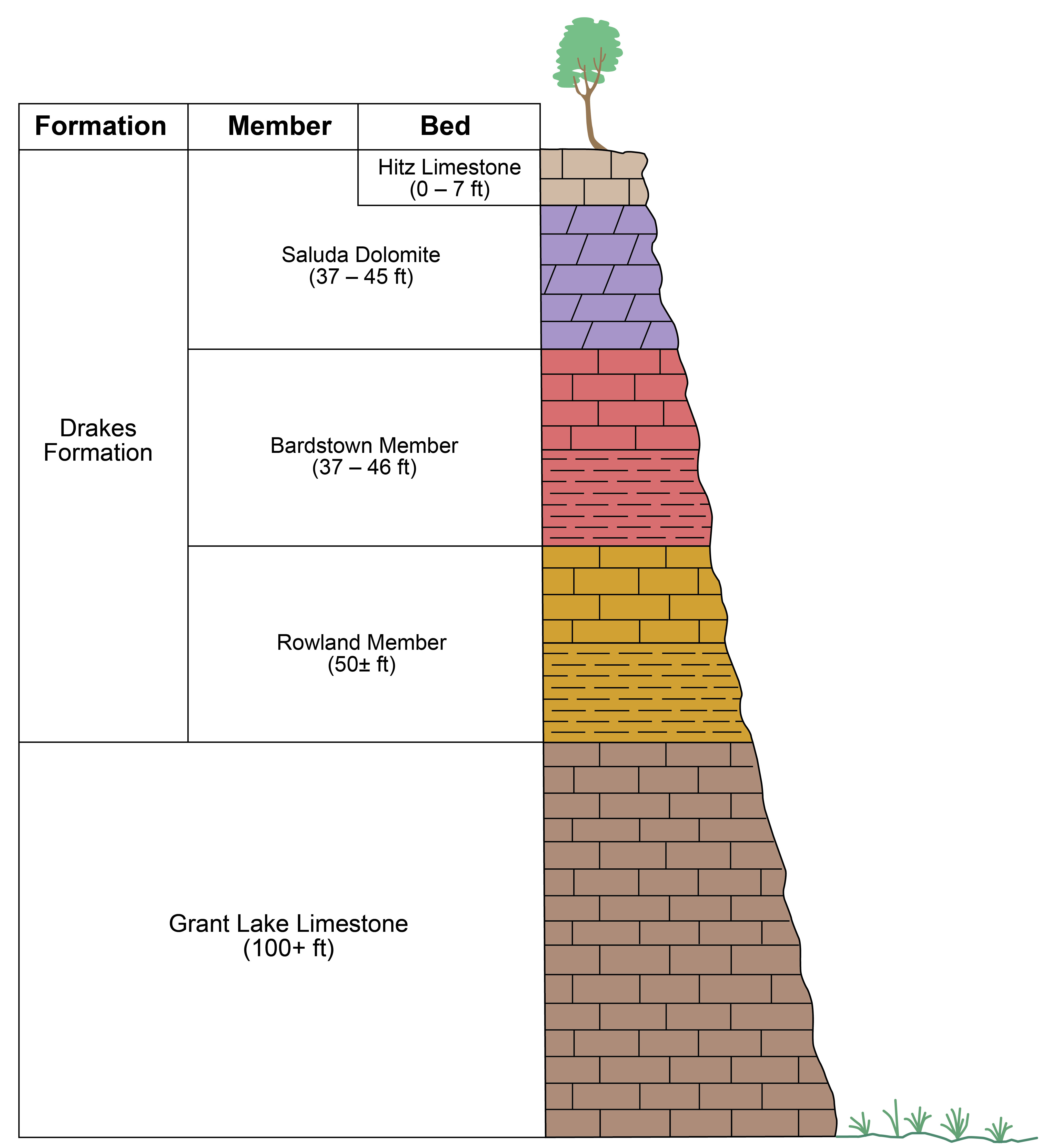
Geologists divide bedrock into different units called beds, members, and formations. Each unit is defined by distinguishing characteristics that allow it to be mapped across broad areas. The oldest bedrock unit exposed along Floyds Fork is the Grant Lake Limestone of Late Ordovician age. It is exposed along cutbanks, which occur along the outer parts of a meandering stream, and in many places along the main channel of Floyds Fork south of Interstate 64. The Grant Lake contains many fossils, especially brachiopods, which are the official state fossil of Kentucky. Brachiopods look like fossil seashells. The Grant Lake is also exposed along the channels of most tributaries to Floyds Fork such as Pope Lick, Long Run, Brush Run, and Cane Run. The Grant Lake Limestone is overlain by the Drakes Formation, which consists of limestone, dolomite, and shale. The Drakes Formation is further divided into members based on the different proportions of limestone, dolomite, and shale, as well as different fossils. The members of the Drakes Formation are the Rowland, Bardstown, and Saluda Dolomite (oldest to youngest). The Rowland Member is exposed along cutbanks and the main stream channel of Floyds Fork north of Interstate 64 and south of U.S. 60. South of Interstate 64, the Rowland underlies the hillslopes and is exposed along small creeks and streams tributary to Floyds Fork. The Bardstown occurs along the slopes of Floyds Fork and tributary streams. The youngest unit along the Parklands of Floyds Fork is the Saluda Dolomite which underlies most ridgetops.

Surficial geology
Unconsolidated, surficial deposits overlie bedrock along most of Floyds Fork. Three general types of surficial deposits are found along Floyds Fork: alluvium, colluvium, and residuum. Alluvium is sediment deposited by water, and occurs in stream valleys. Common alluvial landforms include floodplains, terraces, and alluvial fans. Colluvium is rock and soil moving downslope under the influence of gravity. It covers hillslopes bordering stream valleys, is often thin, and does not have well-developed soils. Residuum is derived from weathered bedrock and occurs in areas of low relief on ridgetops. Residuum in this area is generally thicker than colluvium and is characterized by well-developed soils. When soils are well developed, they contain several distinct horizons, which reflect different amounts of minerals and organic components.
Floyds Fork is a half-mile-wide valley located 15 miles east of downtown Louisville, Ky. It extends 60 miles from the confluence of the north and east forks of Floyds Fork in Oldham County northeast of Louisville, to the Salt River at Shepherdsville in Bullitt County, southeast of Louisville. This tour covers a 7-mile portion of Floyds Fork in the Fisherville 7.5-minute quadrangle, extending from Valhalla Golf Club on the north end to Pope Lick Park of the Parklands of Floyds Fork on the south end. Seven-and-a-half-minute quadrangles are divisions of Earth's surface divided by latitude and longitude; each quadrangle is a rectangular area representing 7½ minutes of latitude by 7½ minutes of longitude. This is the standard mapping area for topographic quadrangle maps, (or approximately 7 x 10 miles) in Kentucky. Geologic quadrangle maps cover the same area, and the geology is mapped on top of the topography. Kentucky is one of the few states in the nation that has been completely geologically mapped on a 7.5-minute quadrangle basis. The scale of both the topographic and geologic maps is 1:24,000.

The location of the Fisherville 7.5-minute quadrangle is indicated on this map.
The tour begins at the William F. Miles Trailhead for the Louisville Loop in Beckley Creek Park (accessed from Beckley Creek Parkway off of Shelbyville Road), and focuses on the bedrock geology and overlying surficial deposits that comprise the Floyds Fork area. Park facilities are shown on this map.
Tour Logistics
The tour path is 8.9 miles in one direction, primarily traveling along the Louisville Loop trail. This tour is best traversed by bicycle, but can also be done by car (stopping at the recommended parking lots described in the text) and then by walking. If traveling by bicycle, please take proper safety precautions: Wear a helmet, be aware that pedestrians have the right of way, and please be courteous to other trail users by signaling your presence (a bell or calling out "On your left" works well). One section of this tour (stops 12 and 13) requires cycling on a lightly travelled road.
Explanation of Stops:
Start: 
Parking lot stop: 
Regular stop: 
Bedrock geology
Floyds Fork is located in the Outer Bluegrass physiographic region, an area characterized by rolling hills and incised plateaus. All of the land within a particular physiographic region has similar geologic structure and topography. The surface topography of the Outer Bluegrass is underlain by limestone, dolomite, and shale. The region typically has low to moderate relief. Soils tend to be thicker over limestone bedrock than over shales, because the ridgetops and valley bottoms are underlain by limestone and hillslopes are underlain by shale. The bedrock across the trail is Late Ordovician in age. The dolomites and limestones contain fossils of corals and marine seashells, which indicates this area was covered by warm, shallow seas during the Late Ordovician Period, from 450 to 443 million years ago.

Geologists divide bedrock into different units called beds, members, and formations. Each unit is defined by distinguishing characteristics that allow it to be mapped across broad areas. The oldest bedrock unit exposed along Floyds Fork is the Grant Lake Limestone of Late Ordovician age. It is exposed along cutbanks, which occur along the outer parts of a meandering stream, and in many places along the main channel of Floyds Fork south of Interstate 64. The Grant Lake contains many fossils, especially brachiopods, which are the official state fossil of Kentucky. Brachiopods look like fossil seashells. The Grant Lake is also exposed along the channels of most tributaries to Floyds Fork such as Pope Lick, Long Run, Brush Run, and Cane Run. The Grant Lake Limestone is overlain by the Drakes Formation, which consists of limestone, dolomite, and shale. The Drakes Formation is further divided into members based on the different proportions of limestone, dolomite, and shale, as well as different fossils. The members of the Drakes Formation are the Rowland, Bardstown, and Saluda Dolomite (oldest to youngest). The Rowland Member is exposed along cutbanks and the main stream channel of Floyds Fork north of Interstate 64 and south of U.S. 60. South of Interstate 64, the Rowland underlies the hillslopes and is exposed along small creeks and streams tributary to Floyds Fork. The Bardstown occurs along the slopes of Floyds Fork and tributary streams. The youngest unit along the Parklands of Floyds Fork is the Saluda Dolomite which underlies most ridgetops.

Surficial geology
Unconsolidated, surficial deposits overlie bedrock along most of Floyds Fork. Three general types of surficial deposits are found along Floyds Fork: alluvium, colluvium, and residuum. Alluvium is sediment deposited by water, and occurs in stream valleys. Common alluvial landforms include floodplains, terraces, and alluvial fans. Colluvium is rock and soil moving downslope under the influence of gravity. It covers hillslopes bordering stream valleys, is often thin, and does not have well-developed soils. Residuum is derived from weathered bedrock and occurs in areas of low relief on ridgetops. Residuum in this area is generally thicker than colluvium and is characterized by well-developed soils. When soils are well developed, they contain several distinct horizons, which reflect different amounts of minerals and organic components.
