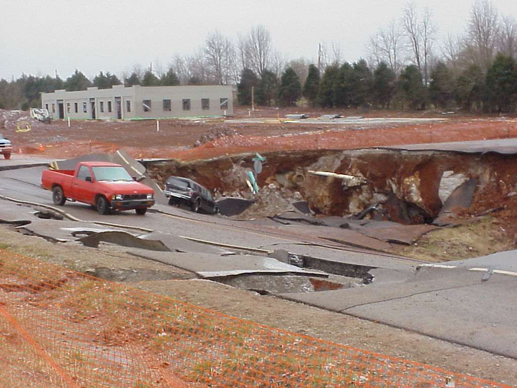
Major Construction
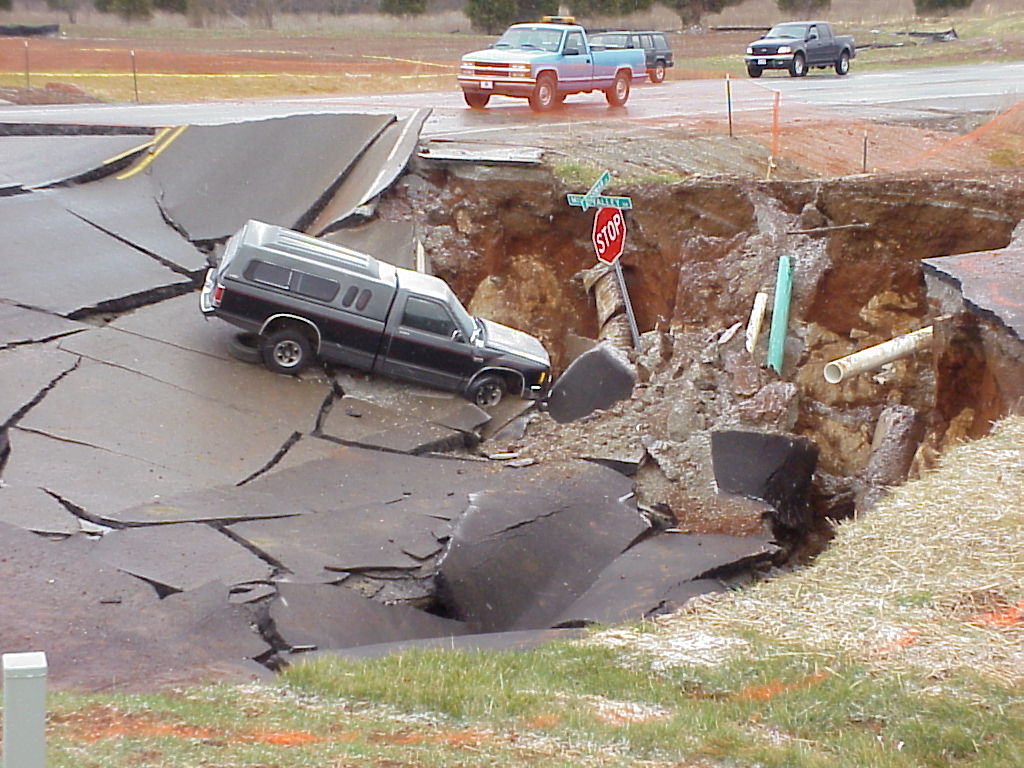
Following geologist's
recommendations can help prevent costly construction failures. (Photos courtesy
of Richard McGehee, Inspector, Field Operations
Branch, Kentucky Division of Water)
Residential Construction
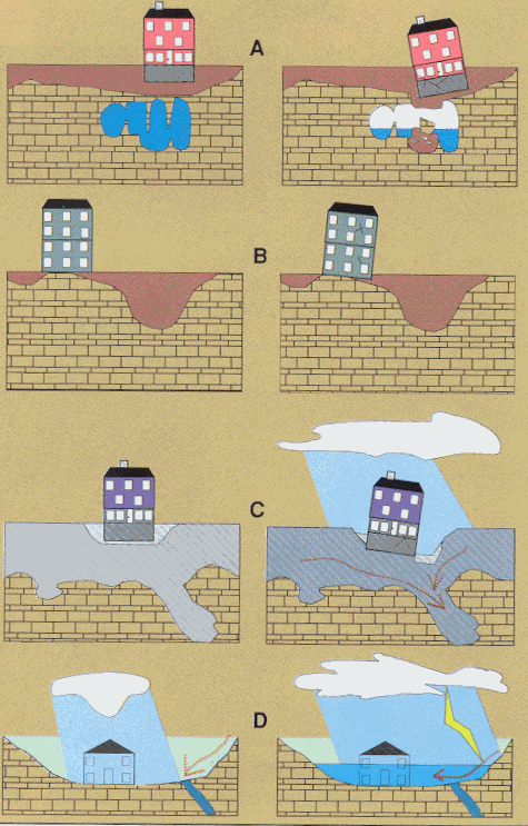
Limestone terrain can be
subject to subsidence hazards, which usually can be overcome by prior planning
and site evaluation. "A" shows construction above
an open cavern, which later collapses. This is one of the most difficult
situations to detect, and the possibility of this situation beneath a structure
warrants insurance protection for homes built on karst
terrain. In "B," a heavy structure presumed to lie above solid
bedrock actually is partially supported on soft, residual clay soils that
subside gradually, resulting in damage to the structure. This occurs where
inadequate site evaluation can be traced to lack of geophysical studies and
inadequate core sampling. "C" and "D" show the close
relationship between hydrology and subsidence hazards in limestone terrain. In
"C," the house is situated on porous fill (light shading) at a site
where surface and groundwater drainage move supporting soil (darker shading)
into voids in limestone (blocks) below. The natural process is then accelerated
by infiltration through fill around the home. "D" shows a karst site where normal rainfall is absorbed by subsurface
conduits, but water from infrequent heavy storms cannot be carried away quickly
enough to prevent flooding of low-lying areas. (Adapted from
American Institute of Professional Geologists, 1993).
Environmental Protection
- Never use sinkholes as dumps. All waste, but especially
pesticides, paints, household chemicals, automobile batteries, and used
motor oil should be taken to an appropriate recycling center or landfill.
- Make sure runoff form parking lots, streets, and other
urban areas is routed through a detention basin and sediment trap to
filter it before it flows into a sinkhole.
- Make sure your home septic system is working properly
and that it's not discharging sewage into a crevice or hole.
- Keep your cattle and other livestock out of sinkholes
and sinking streams. There are other methods of providing water to
livestock.
- See to it that sinkholes near or in crop fields are
bordered with trees, shrubs, or grass "buffer strips." This will
filter runoff flowing into sinkholes and also keep tilled areas away from
sinkholes.
- Construct waste-holding lagoons in karst
areas carefully, to prevent the bottom of the lagoon from collapsing,
which would result in a catastrophic emptying of waste into the groundwater.
- If required, develop a ground-water protection plan
(410KAR5:037) or an agricultural water-quality plan (KRS224.71) for your
land use. (From Currens, 2001).
Pond Construction
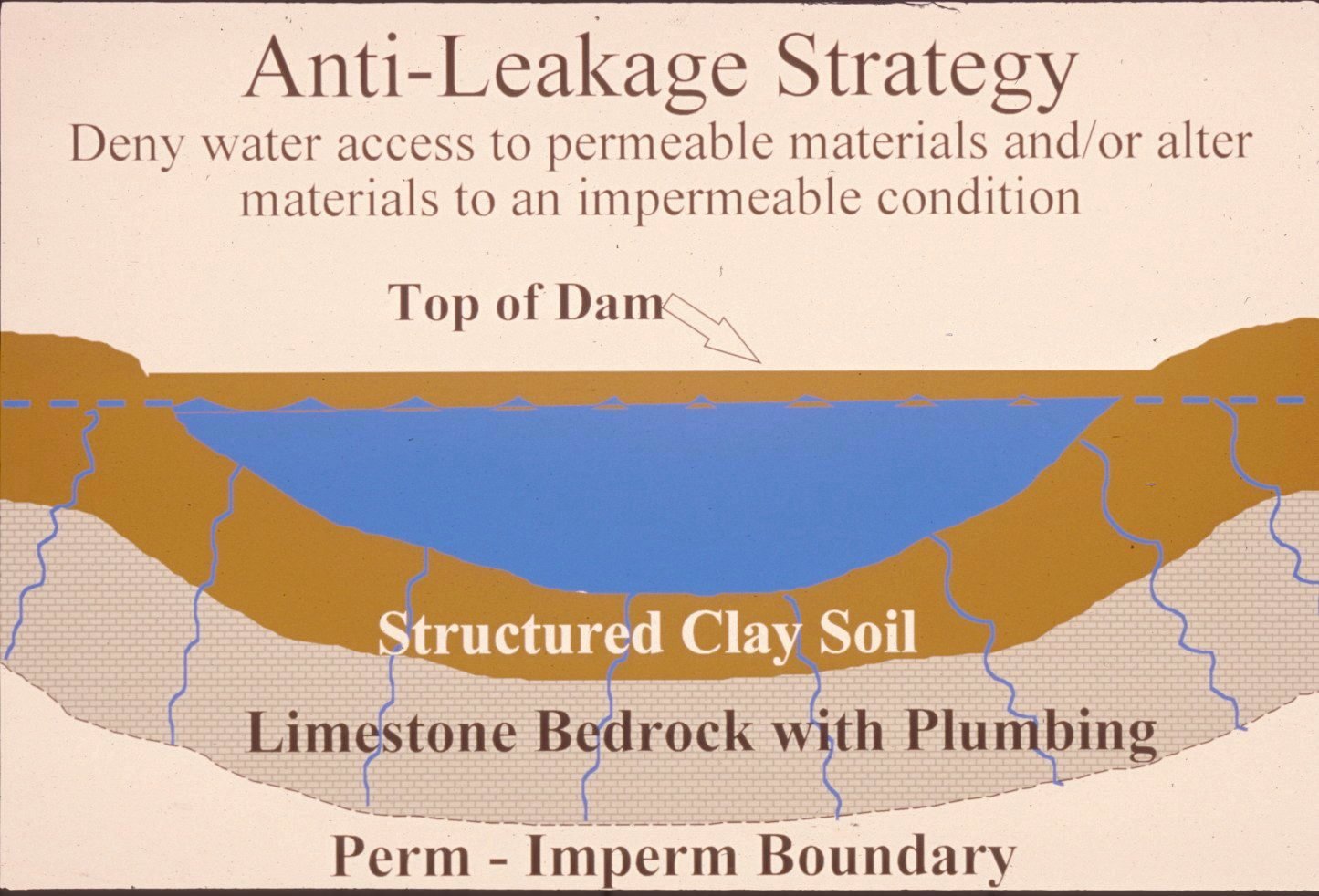
Successful pond
construction must prevent water from seeping through structured soils into
limestone solution channels below. A compacted clay liner, or artificial liner,
may prevent pond failure. Getting the basin filled with water as soon as
possible after construction prevents drying and cracking, and possible leakage,
of the clayey soil liner. Ponds constructed in dry weather are more apt to leak
than ponds constructed in wet weather. (illustration
and discussion by Paul Howell, USDA-NRCS)
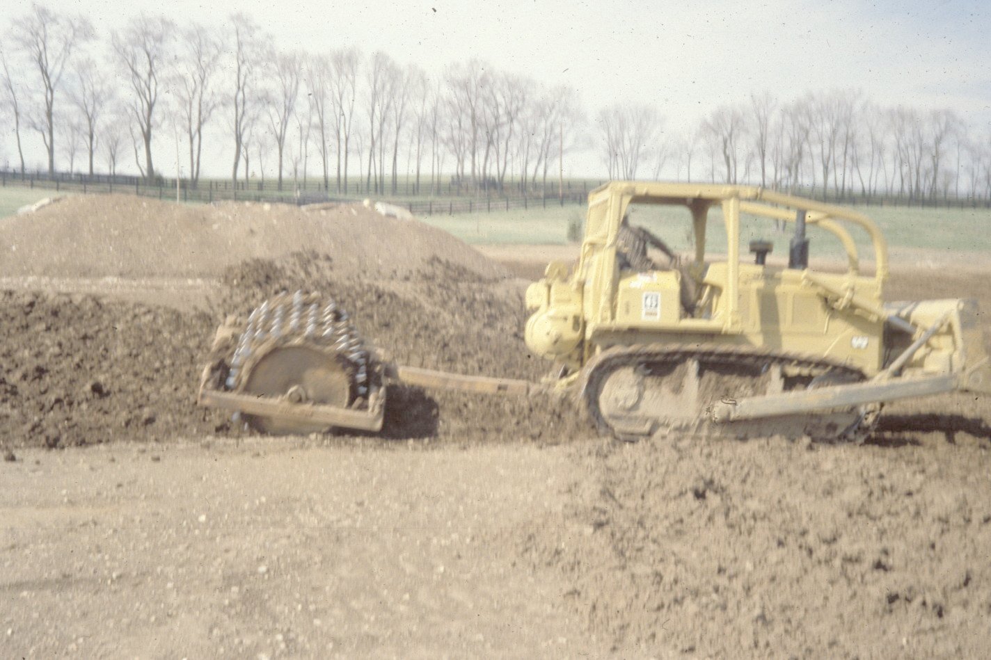
A clayey-soil pond liner is
placed in loose, moist layers and compacted with a sheepsfoot
roller. A geotechnical engineer or geologist should be consulted regarding the
requirements of a specific site. Other leakage prevention measures include
synthetic liners, bentonite, and asphaltic
emulsions. The U.S. Department of Agriculture-Natural Resources Conservation
Service can provide guidance on the application of these liners to new
construction, and for treatment of existing leaking ponds. (photo
and discussion by Paul Howell, USDA-NRCS)
Dams should be constructed
of compacted clayey soils at slopes flatter than 3 units horizontal to 1 unit
vertical. Ponds with dam heights exceeding 25 feet, or pond volumes exceeding
50 acre-feet, require permits. Contact the Kentucky Division of Water,
Geologic Hazards
Mapped Surface Faults
Faults are common geologic
structures across
Faults may be associated
with increased fracturing of bedrock in the immediately adjacent area. This
fracturing may influence slope stability and groundwater flow in these limited
areas.
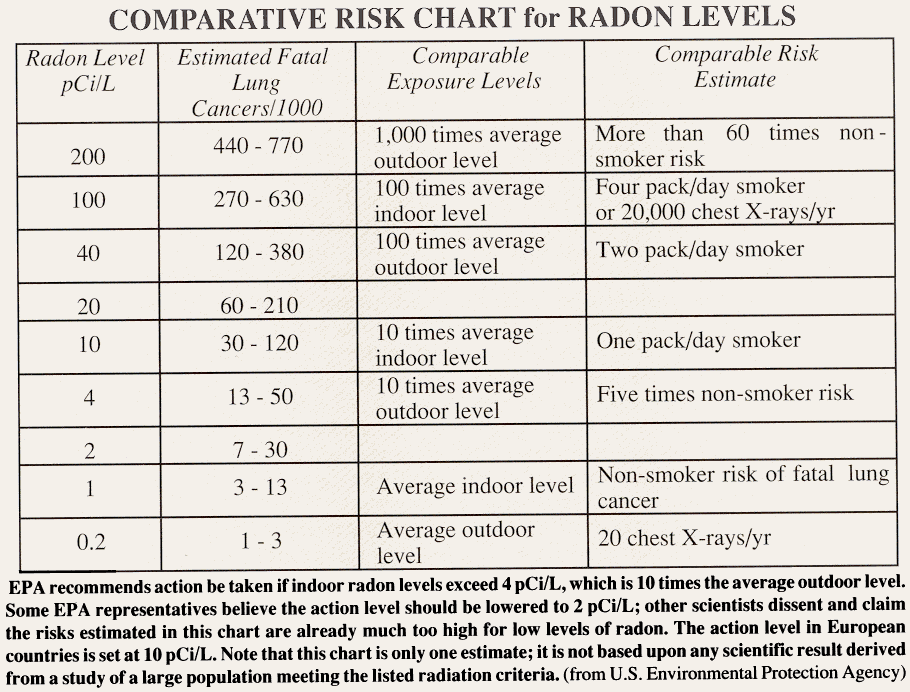
Radon
Radon gas can be a local
problem, although it is not widely distributed in
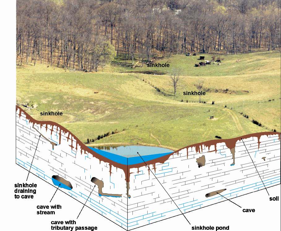
Groundwater
In karst
areas such as
In the upland regions of
References
American
Barton, A.J., Dye, J.W., Mitchell,
M.J., Craddock, W.H., Campbell, E.B., Owen, D.E., and Holbrook, D.W., 1981,
Soil survey of Warren County,Kentucky: U.S. Department of Agriculture, Soil
Conservation Service, 114 p.
Carey, D.I., and Stickney,
J.F., 2001, Groundwater resources of Warren County, Kentucky: Kentucky
Geological Survey Open-File Report OF- 01-114, 29 p.
Currens, J.C., 2001, Protecting Kentucky's karst aquifers from nonpoint-source
pollution: Kentucky Geological Survey, ser. 12, Map and Chart 27, poster.
Paylor, R.L., Florea,
L.J., Caudill, M.J., and Currens, J.C., 2003, A GIS
coverage of sinkholes in karst areas of
Ray, J.A., and Currens, J.C., 1998, Karst
groundwater basins in the Beaver Dam 30x60 minute quadrangle: Kentucky
Geological Survey, ser. 12., Map and Chart 19, scale
1:100,000.
Ray, J.A., and Currens, J.C., 2000, Karst
groundwater basins in the
Thompson, Mark F., and
others, 2003a, Geologic Map of the Bowling Green 30x60 Minute Quadrangle,
Central Kentucky: Kentucky Geological Survey, Series XII,Geologic
Map, Scale 1:100,000.
Thompson, M.F., and others,
2003b, Geologic Map of the Beaver Dam 30x60 Minute Quadrangle, Central
Kentucky: Kentucky Geological Survey, ser. 12, Geologic Map, Scale 1:100,000.
Copyright
2003 by the University of