Union County, Kentucky
Geologic Hazards
The most prominent geologic hazard for Union County
is flooding. Areas underlain by alluvium are often subject to flooding. Urban
development exacerbates flooding, and therefore potential flooding should
always be considered in urban development plans. Areas of steep-walled
drainage, such as that formed in terrain underlain by shale, sandstone, and
limestone units, are conducive to flash flooding, especially in developed
areas. Maps of flood-prone areas may be obtained from the Kentucky Division of
Water--Floodplain Management Branch, Federal Emergency Management Agency, or
the U.S. Geological Survey.
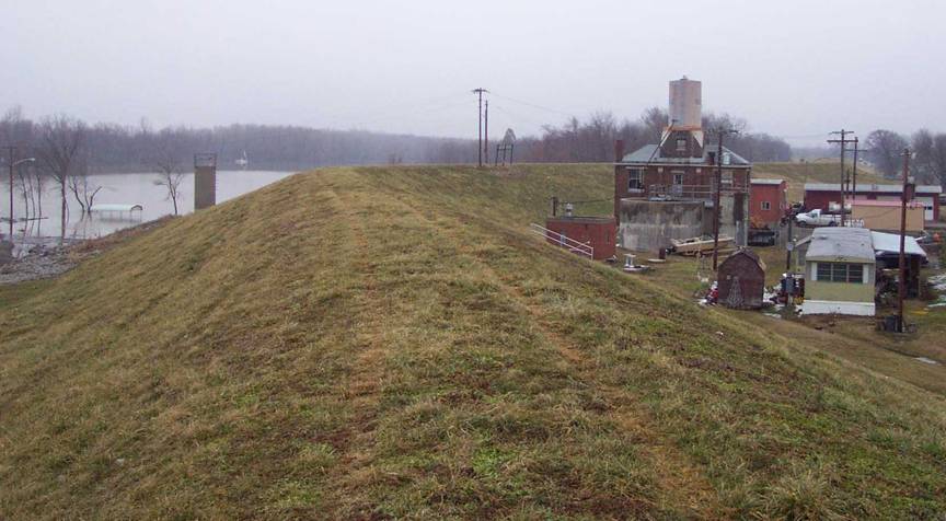
The Uniontown levee
was constructed to hold back Ohio River flood
waters. There is also an earthen levee constructed
around the city of Sturgis. Photo by Glynn Beck, Kentucky
Geological Survey.
None of the faults that occur in Union
County are considered active; however,
the proximity of active seismic zones, such as the New Madrid,
Wabash, or East Tennessee, calls for
precautions to be taken for earthquake damage mitigation. The presence of thick
alluvium, which normally has a high water table, should also be treated with
special concern because of the possibility of augmented shaking and liquefaction
during a strong earthquake. In addition, alluvium often contains high amounts
of clay minerals, which can give a soil a high shrink/swell capacity.
Earthquake Hazard
Information
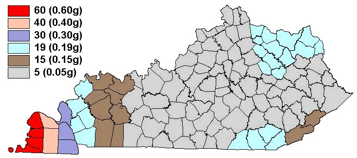
Peak ground
acceleration at the top of rock that will
probably occur in the next 500 years in Kentucky
Although we do not know when and where the next major
earthquake will occur, we do know that an earthquake will cause damage.
Severity depends on many factors, such as earthquake magnitude, distance from
the epicenter, and local geology. Information on earthquake effects is obtained
by monitoring earthquakes and performing research. Such information is vital
for earthquake hazard mitigation and risk reduction.
The most important information for seismic-hazard mitigation
and risk reduction is ground-motion hazard. One way of predicting ground-motion
hazard is by determining the peak ground acceleration (PGA) that may occur in a
particular timeframe. The map above shows the PGA at the top of bedrock that
will likely occur within the next 500 years in Kentucky (Street and others, 1996). It
shows, as expected, that PGA would be greatest in far western Kentucky near the New Madrid Seismic Zone.
Ground-motion hazard maps for the central United States and other areas are available
from the U.S. Geological Survey. These maps are used to set general policies on
mitigating damage. For example, maps produced by the USGS in 1996 were used to
determine seismic design in building codes. For additional information about
earthquake hazards, visit the Kentucky Geological Survey Web site at www.uky.edu/KGS/geologichazards/geologichazards.html.
Other
Hazards
Steep slopes are present, especially along streams in areas
underlain by shale, sandstone, and limestone, throughout the county. Steep
slopes can develop soil creep and landslides if not properly treated during
development. Proper engineering techniques should be followed when developing
on hillsides, and care should be taken not to affect property above and below a
development site on a hillside.
Several underground coal mines are located in Union County.
The locations of known mine workings and shafts are shown on the map.
Precautions need to be taken when developing over old mined areas because of
the possibility of subsidence. Mine subsidence insurance is available in Kentucky. Abandoned mine
boundaries shown on the map are approximate and do not represent all the mining
that has occurred in the county.
Soil piping, which may occur in various soil types, but
particularly in alluvium and loess, produces small to large holes if left
untreated. The only way to treat soil piping is to fill the holes with rock or
soil to keep the holes from enlarging and to divert drainage from the area.
Agriculture
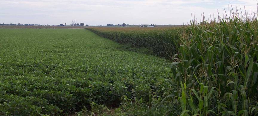
Agriculture is a
major part of the Union
County economy. Of the
218,343 acres in Union
County, 128,000 (59
percent) were planted with either corn or soybeans in 2002, according to the Kentucky
Agriculture Statistics Service. Photo by Glynn Beck,
Kentucky Geological Survey.
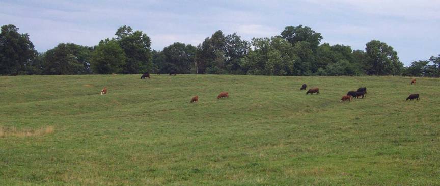
The
topography of Union County ranges from flat bottomlands along the Ohio River to rolling uplands with steep slopes. Generally,
steep slope areas are not suitable for row crop and are utilized for pasture. In
2003 there were approximately 18,000 head of cattle in Union County
(Kentucky Agriculture Statistics 2002-2003). Photo by Glynn Beck, Kentucky
Geological Survey.
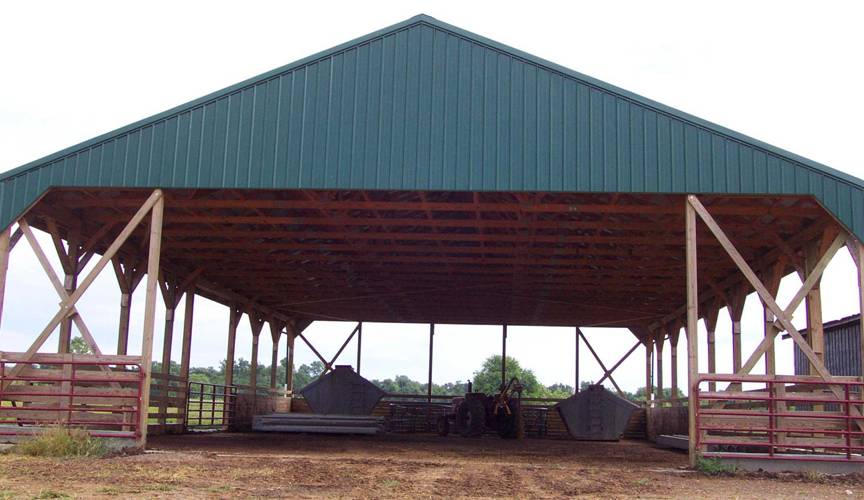
Cattle feeding
shelters, like the one above located on Gough Farms,
are being utilized by farmers in Union
County to minimize manure
concentrations on the land surface. These shelters help reduce nutrient
contamination to surface water and groundwater. Photo by Glynn Beck, Kentucky
Geological Survey.

Farmers use
groundwater to irrigate their crops planted in bottomlands along the Ohio River. Photo by Glynn Beck, the Kentucky Geological
Survey.
Energy
Resources
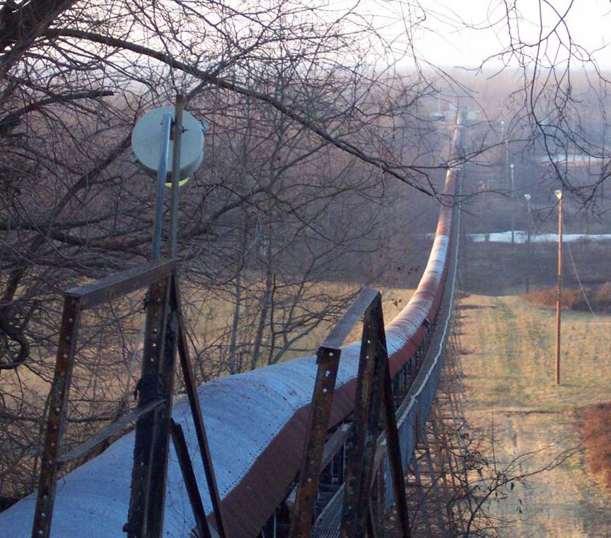
Coal mining continues
to be a vital part of the Union
County economy. The
conveyor pictured above was constructed by Nashville Coal in the early 1950’s.
The belt was started on March 3, 1953, and carried 15 tons per minute for a
half mile through Union
County. Nearly 3.8
million tons of coal were taken from underground mines
in 2002. Photo by Glynn
Beck, Kentucky
Geological Survey.
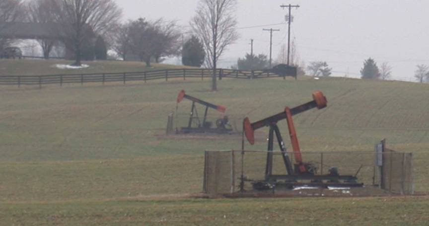
Oil well pump jacks
are located throughout Union
County. More than 1,100
producing oil and gas wells have been completed in Union County.
Photograph by Glynn Beck, Kentucky Geological Survey.
Surface-Water Drainage
Because of the large
percentage of flat to gently sloping areas associated with the Ohio and Tradewater Rivers,
development, such as subdivisions, can cause flooding if proper drainage
designs are not implemented as part of the planning and development process.
Watersheds can also be impaired from improper sewage treatment and urban and
industrial runoff.
Groundwater
The alluvium along
the Ohio River is the best source of
groundwater in the county. In the northern and western edges of the county,
nearly all drilled wells less than 150 feet deep in the alluvium of the Ohio River valley are adequate for domestic use. Most
wells yield more than 50 gallons per minute, and some yield as much as 1,000
gallons per minute. In over half of Union
County most wells that
penetrate sandstone formations less than 300 feet are adequate for a domestic
supply.
In the highlands of
the southeastern part of the county, in the old Camp Breckinridge
area, and in the Grundy Hill area southwest of Uniontown, only a few wells
yield enough water for a domestic supply. In a thin, highly faulted zone
running east-west across the county between the towns of Givens and The Rocks,
yields to drilled wells are unpredictable because of the faulting.
Generally,
groundwater is hard to very hard, and iron and salt may be present in
objectionable amounts. Often groundwater becomes saltier with depth.
For more information
on groundwater resources in the county, see Carey and Stickney (2001).