Introduction to the Oil and Gas Well Shapefile: KYOG83
Version 10, 10-May-2005
Contact: Brandon Nuttall
Some links in this document require an active connection to the Web. This version of the documentation has been prepared for distribution with the oil and gas maps of Kentucky on CD-ROM; all
references to "kyog83v10" apply to the ogwells shapefile.
Copyright
Data and images in this distribution are copyrighted (2005) by the Kentucky Geological Survey, University of Kentucky. The user is granted the right to use these data to produce maps, charts, and
reports. The user of these data is further granted the right to provide copies of the oil and gas well-data shapefiles included as described in this document provided:
- The data are distributed in their original form, as acquired from the Kentucky Geological Survey or downloaded from its Web site.
- This documentation, including the notice of copyright and disclaimer, are provided without modification.
If you have acquired these data from a third party, the Kentucky Geological Survey invites you to visit our Web site.
Disclaimer
Data in this file are presented as is with no warranty either expressed or implied as to the completeness or accuracy of any location or well status. Data on file at the Kentucky Geological Survey
are submitted by well operators under requirements established by Kentucky Revised Statute 353. The producing or abandoned status of any well is dependent on the completion type reported by the
operator on the well log and completion report, on the availability of a plugging affidavit, and on other information or maps on file in the Public Information Center of the Kentucky Geological
Survey.
Some wells in the database have duplicate locations (sometimes more than one well at a given location). As in the case of workovers and deepenings of existing wells, this is intended. However, in
the recent conversion of our database to new software on a new server, some valid locations were inadvertently duplicated to wells that have no location. These wells are being identified and
corrected. Suspect invalid duplication if there are significantly more than four or five entries at a given location and the location is in the middle of a 1-minute or 5-minute Carter coordinate
section or the middle of a 7.5-minute quadrangle. Your assistance in this matter is requested and appreciated.
A note on the wells included in this distribution
The wells in this distribution include only those wells for which a complete Carter coordinate location is available; that is, only wells for which latitude and longitude can be calculated. For
most areas in Kentucky there are wells for which we have insufficient location data to determine latitude and longitude. To obtain data for wells for which only the county, 7.5-minute quadrangle, or
partial Carter coordinate are known, copies of the electronic data must be obtained.
What's new
V10: Updated data set with new wells permitted and completed to 10-May-2005. Added data field SAMPLES to indicate avaiability of cuttings and cores at the Kentucky Well Sample and Core Library.
V9: Provisional data set, not for public release.
V8: Updated data with new wells permitted and completed to 8-Apr-2004. Added ArcView/ArcGIS projection file (kyog83v8.prj) and ArcGIS metadata file. Documentation has been converted to an html format compatible with most web browsers.
V7: Updated data with new wells permitted and completed to 6-Feb-2003. Added IOF_IP field. Incorporated location revisions; a calculation error affecting about 1,000 wells was discovered
and corrected. The former Geologic Data Center at the Survey is now known as the Public Information Center.
V6: Updated data with new wells permitted and completed to 7-Nov-2002. Added elevation field. Included abandoned well locations (expired or cancelled, i.e., "terminated" permits).
V5: Updated data with new wells permitted and completed to 10-Oct-2001.
V4: Regional location data fields have been added to provide easier extended searching capabilities: the county and topo names and the Carter coordinate section, letter, and number.
V3: This distribution contains more identifying data (operator, well number, and farm name) that will enable users to better access the well records on file in the Public Information Center at
the Kentucky Geological Survey. The completion data for wells and their abandoned status are also included.
Production data
Limited production data by well are available at the Kentucky Division of Oil and Gas Web site. Oil and gas production data by county are available in the Division's Technical Information Library.
Datum
Location data in this shapefile are supplied as latitude and longitude in both North American datums of 1927 and 1983 (NAD27 and NAD83). The shapefile kyog83v10.shp was created using location
values from the two fields: Lat83 and Lon83. The file kyog83v10.dbf can be loaded into ArcView as a table, and the fields "Lat27" and "Lon27" can be used to create a shapefile projected to the NAD27
datum. Latitude and longitude are expressed as decimal degrees for both datums. By convention, west longitude is expressed as a negative number.
Base map data
These locations are best used posted on a base map. Base maps for displaying these data may be downloaded from the Kentucky Geological Survey Web site.
A note on samples available
The Kentucky Geological Survey maintains the Well Sample and Core Library where samples acquired during drilling or augering are catalogued and stored. These samples are available for inspection and limited analysis. For information, check the website or call Patrick Gooding or Ray Daniel at 859-389-8810.
Components of the kyog83v10 shapefile
KYOG83 is a zipped archive file containing an ArcView shapefile that provides an introduction and overview of the oil and gas well data available in Kentucky. This shapefile was created using
ArcView 3.2. These data may be viewed with ArcView, ArcExplorer, or any software that supports shapefiles. ArcExplorer is a free viewer available for downloading at the site (visited 10-May-2005).
The kyog83v10 shapefile contains data for 130,960 oil and gas well locations in Kentucky and consists of seven separate files:
- kyog83v10.AVL (an ArcView legend file, not required for plotting)
- kyog83v10.DBF (the data attribute file, which can be imported into Access, etc.)
- kyog83v10.PRJ (ESRI projection file for GIS systems that automatically recognize projection data)
- kyog83v10.SBN
- kyog83v10.SBX
- kyog83v10.SHP
- kyog83v10.SHP.xml (FGDC metadata file created by ArcCatalog 8.3)
- kyog83v10.SHX
- kyog83v10_metadata.htm (FAQ-style metadata file exported from kyog83v10.SHP.xml for use in standard web browser)
- ogwells.html (this documentation file, open with a web browser--Internet Explorer, Netscape, or other)
Data supplied for each well
| Recno |
Unique identifier for each well in the KGS database |
| Permit |
Permit issued by the Kentucky Division of Oil and Gas |
| Operator |
Well operator of record when the well was originally drilled (truncated to 16 characters) |
| Well |
Well number assigned by operator |
| Farm |
Farm or lease name (usually mineral owner in the case of severed minerals, truncated to 16 characters) |
| County |
County in which the well is located |
| Topo |
Name of the 7.5-minute quadrangle in which the well is located |
| Elev |
Ground-level elevation of the well in feet above sea level |
| Sec |
1-minute Carter coordinate section in which the well is located (1 to 25) |
| Ltr |
5-minute Carter coordinate section letter (" A" to " Z" and "AA" to "GG") |
| Num |
5-minute Carter coordinate section number (0 to 92) |
| TD |
Total depth of the well in feet |
| Tdfm |
Name of the formation penetrated at the total depth of the well. Formation codes are derived from the American
Association of Petroleum Geologists stratigraphic code. |
| Result |
Completion type of well (see table of values). Note that the results codes supplied in this data set have been generalized from the results available in the main Oil and Gas Well Record Database. See the FAQ on result codes for more information
|
| IOF_IP |
Initial open flow (IOF) for gas wells or initial potential (IP) for oil wells. These data are reported for the deepest or only producing interval (pay). Wells with commingled production may not have IOF or IP in this database.
BOPD: barrels of oil per day
BOPH: barrels of oil per hour
DISP: the deepest pay reported is a disposal zone
INJECT: the deepest pay reported is an injection zone
MCFGPD: thousand cubic feet of natural gas per day
MMCF: million cubic feet of natural gas per day
SUPPLY: the deepest pay reported is a water-supply zone
|
| DeepestPay |
Name of the deepest or only producing formation (AAPG codes same as above) |
| cdate |
Date well was completed, if known |
| Abnd |
Value of -1 indicates the well is abandoned (see especially abandoned producers); otherwise the value is 0 |
| Elog |
Value of -1 indicates an electric log is on file at the KGS; otherwise the value is 0 (no log on file) |
| Samples |
Indicates availability of samples at the Kentucky Well Sample and Core Library
CUT: drill cuttings
CORE: core or core chips
|
| Lat27 |
North latitude of well in decimal degrees (NAD27) |
| Lon27 |
West longitude of well in decimal degrees (NAD27) |
| Lat83 |
North latitude of well in decimal degrees (NAD83) |
| Lon83 |
West longitude of well in decimal degrees (NAD83) |
Key to values for the result field
| D&A |
Dry and abandoned wells (Abnd = -1 by default) |
| GAS |
Wells completed as gas wells (including abandoned producers) |
| LOC |
Newly permitted locations or historic wells for which completion data are not available in the KGS database |
| MSC |
Miscellaneous well types, including cathodic protection, observation, water supply wells, and others |
| O&G |
Wells completed as combined oil and gas producers (including abandoned producers) |
| OIL |
Wells completed as oil (including abandoned producers) |
| SRV |
Secondary recovery input, water injection, and other miscellaneous well types associated with secondary or enhanced oil recovery (EPA Class II wells) |
| STR |
Stratigraphic tests released to the public (Abnd = -1 by default) |
| TRM |
Locations for which a permit was issued but the permit was cancelled by the operator or allowed to expire. Wells with this designation are included to enable tracking the status of
permits. |
By State law, data for wells permitted as stratigraphic tests are held permanently confidential, unless information is released by the operator directly to the Kentucky Geological Survey and
designated by the operator to be publicly available. Those wells designated as "STR" in the data file have been publicly released. When electronic data are provided as lists or databases, these
publicly released stratigraphic tests are designated "STRP." For a time, an operator was allowed to convert a well drilled as a stratigraphic test to another purpose. This practice led to producing
wells for which no information was publicly available. To eliminate this, a policy was adopted that all wells permitted as stratigraphic tests must be plugged, and no conversions are allowed. Thus,
there may be a few stratigraphic tests for which a producing interval is reported; these wells are assumed to be abandoned.
Digital well data resources at the Kentucky Geological Survey
The database provided with this distribution is limited in scope. These data were initially used to compile "Distribution of Oil and Gas Wells in Kentucky" (Carey, D.I., and Nuttall, B.C., 1995–, Kentucky Geological Survey, ser. 11, Map and Chart 9, scale 1:1,000,000
) and are designed to
accompany various base maps available through the Kentucky Geological Survey Web site.
Additional details for each well are available in electronic form. Subsets of the data may be specified. Well data may be selected based on counties, Carter coordinates, quadrangle, latitude and
longitude bounded areas, depth of penetration, available records, and other parameters. For example, a database of the wells in Leslie and Perry Counties that penetrate the Devonian shale or deeper
zones and have lithodensity logs may be created. Data are distributed by electronic mail. For larger databases, the information can be written to CD-ROM or posted to an anonymous ftp site for
downloading.
The cost for digital well-record data that include latitude and longitude and stratigraphic tops is $10 plus a per well charge of $0.15. Kentucky sales tax, postage, and handling will be charged
for data supplied as an attachment to electronic mail or on CD-ROM. MasterCard and VISA are accepted. You may place an order by email to Brandon C. Nuttall or by phone at 859-257-3896 (or
toll-free at 877-778-7827).
Online oil and gas well records
The Kentucky Geological Survey has implemented an online oil and gas well-data search facility. Data may be accessed using a selection of predefined queries or through an interactive Internet map
server. Scanned images of oil and gas well records, including electric and geophysical logs, are available for viewing, printing, or downloading. More information on these services is available on the KGS Web site. For first-time users, tutorial and help files are available online. The free DjVu browser plug-in is required to view the online records, and the
online documentation files include instructions on downloading and installing DjVu.
In addition to the interactive query and map server applications, the Kentucky Geological Survey has implemented the following services:
- KGS GeoPortal: This is the gateway to a variety of interactive map servers implemented by State, County, and City governments. A geographic names index and other options are available for locating an area of interest.
- KGS Coordinate Conversion Tool: This tool provides a method to perform coordinate conversions and datum changes that include the Kentucky State Plane Single Zone and the Carter coordinate grid locations.
- KGS Create an Oil and Gas Gathering Line Map Tool: New regulations require gathering line maps to be submitted to the Kentucky Division of Oil and Gas. This tool is provided to assist operators without geographic informations systems software to comply with the regulation. For information and application forms, see KAR 1:190.
Other base-map data
Georeferenced images are available for topographic, geologic, and aerial photographic maps at various Web sites. In general, single maps may be downloaded for free, or prepared CD-ROM's of multiple maps
may be purchased. Note that these base-map data files are projected to State Plane (north zone, south zone, or the new single zone) or UTM coordinates; GIS software is required to align the oil and
gas well-record data file with these base maps. Most maps are now available for downloading at the KYMartian download center.
Many of these maps have been trimmed and edgematched to allow seamless joining of adjacent maps. Images and georeferencing data are often compressed together into a single file. You will need
WinZip to decompress the distribution file. Be sure to read documentation available for each image type; georeferencing information (the "world" file) must be downloaded separately for some image
types. Some images are supplied using MrSID compression. The MrSID viewer (now called Express View) and plug-ins are available for free from Lizardtech. The distribution files have been provided in the Viewer subdirectory on this CD-ROM.
To use MrSID files with ArcView, you must enable the MrSID extension. Version 2 of the free GIS viewer, ArcExplorer, includes MrSID support. The Java versions of ArcExplorer do not support MrSID
formats at this time.
Making an oil and gas map with ArcExplorer
ArcExplorer is not a full-featured GIS, and the resulting map of Kentucky will be unprojected; that is, the map will appear compressed north to south and stretched east to west. In addition,
because all coordinates are geographic (decimal degrees of latitude and longitude), the topographic map and Carter coordinate grids will appear square. For simplicity, this tutorial will assume that
the necessary files have been installed on your hard drive in the temporary directory (c:\temp).
- Create a directory for the data and base map files for this project, then download these files to that directory.
- If you don't have it, download ArcExplorer version 2, and install it. ArcExplorer2 is suggested because it
supports MrSID image compression. The ArcExplorer 2 setup file is included in the Viewer subdirectory on this CD-ROM. A Java-based version, ArcExplorer 9.1, is also available. If you have the current Java Runtime Environment installed and are not interested in MrSID images,
ArcExplorer 9.1 has a more flexible Web data interface. ArcExplorer 9.1 is available from ESRI. These instructions are
for ArcExplorer2, but the differences are minimal. Hint: After installation, point to any button on the tool bar to find out what it does.
- Download KYOG83.ZIP.
- You also might want to download FAULTS.ZIP (surface faults digitized from the 1:500,000-scale geologic map of Kentucky).
- Download COUNTY.ZIP.
- Optional files to download:
- CARTER1.ZIP - 1-minute Carter coordinate grid
- CARTER5.ZIP - 5-minute Carter coordinate grid
- QUADSKY.ZIP - grid of topographic map boundaries.
- To extract the data files from the compressed archive, you will need WinZip. Unzip the shapefiles to the directory you created for the
download.
- Start ArcExplorer and click OK to close the tip window. Make sure the "Local" tab is selected in the table of contents window.
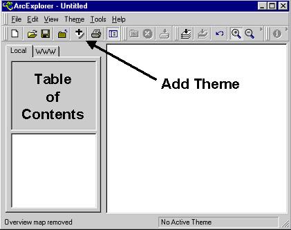
- Add themes to the view by clicking on the "Add Theme(s)" button (the plus to the left of the button with the printer icon on the toolbar). Navigate to the directory where your themes are stored.
To select multiple themes, click on one then press the control ("Ctrl") key and click other themes. Once selected, click the "Add Theme" button in the dialog box and close it.
- Add the kyog83v10 theme.
- Add the COUNTY theme.
- Format the view:
- In the table of contents window to the left of the map window, the oil and gas well shapefile should be first (on top), with the county data following. If not in this order, click and drag the
entries to the correct order.
- Click the check box next to its title to enable display of the county boundary file.
- Change the county shapefile legend:
- Click the county shapefile entry in the table of contents to make it the active theme.
- Click Theme | Theme Properties or double-click on the entry to open the Theme Properties dialog box.
- Double-click the color panel and change the foreground color to light blue.
- Click "Apply" then close the properties window.
- Change the oil and gas well legend:
- Double-click the kyog83v10 entry in the table of contents menu.
- Choose unique values in the classification options box and set the field name to RESULT.
- Either accept the default colors and symbols, or click on the symbol(s) you want to change and make selections from the dialog box. If you set the style to a True Type marker, then any symbol
from any of your installed fonts may be used.
- Optional: Add Carter coordinate or topographic map grid themes. To see wells, make sure to set the style to "Transparent fill" in the theme properties dialog box.
- To identify wells:
- Click on the well data theme, kyog83v10, in the table of contents to make it the active theme. It will be highlighted.
- Zoom in on the map by clicking on the magnifier button on the tool bar, then click and drag a zoom box in the map area. To zoom back out, click on the "Zoom to Full Extent" button (a black
down-pointing arrow over three stacked sheets).
- Click the identify button (black circle with a white "i"), then point to a well and click to open the "identify results" dialog box.
- Other themes may be downloaded to provide information on streams, roads, populated places, and other features.
- Note that the themes used in this demonstration and provided on the Web were designed to be manipulated with a full-featured GIS so they can be matched with DRG, DOQQ, and other map elements
available on the Web.
More information
If you have any questions or problems, contact:
Brandon C. Nuttall
Kentucky Geological Survey
228 MMRB
University of Kentucky
Lexington, KY 40506-0107
Phone: 859-257-5500x174
Email: bnuttall@uky.edu
© 2003, 2004, 2005 Kentucky Geological Survey, University of Kentucky
Created 4-Mar-2003